AI Turns the Earthquake Game: Case Studies from Around the World
Earthquakes are natural disasters that we can hardly predict anything. However, it caused severe damage to both life and property in the blink of an eye.
But did you know that in an era where Artificial Intelligence (AI) is getting smarter every day? This technology is completely changing the way we deal with earthquakes. From what I used to do, I could only wait for the incident to occur and then fix it. AI is now helping us to be 'proactive defensively' like never before.
I was one of the victims of the earthquake, running away from a tall building like many others. On the afternoon of Friday, March 28, 2025, and with curiosity, curiosity, and curiosity. As a workplace related to AI, I tried to do more research to see how useful AI can be and help with natural disasters such as earthquakes.
This article will take you to look at real cases from around the world on how AI is not just an auxiliary tool, but is becoming an important 'key' to protecting us from this major disaster.
1. Digital Eyes: AI Illuminating the damage after the earthquake
Imagine the big earthquake just calmed down. The first thing to know is 'how damaged it is' so that you can quickly send help to the right place. This is what AI is good at.
Modern damage assessment systems use what's known as Convolutional Neural Network (CNN) which has high ability in image analysis.
It works similarly. Intelligent 'Digital Eyes' It scans satellite imagery or aerial imagery and targets the damage to buildings. It is very fast and accurate.
- In Hiroshima Japanese: Researchers here create a CNN model that 'looks' Aerial images can tell which buildings have collapsed and how much damage they have done, with 94% accuracy and only a few minutes!
- In Hokkaido, Japan (2018): After the earthquake AI is used to help find landslide detection from satellite images in 5 minutes!
- Turkey-Syria Earthquake (2023): AI played a really important role in that traumatic incident. xView2 Project Help build Damage Mapping Very fast. This made the rescue team know where to rush first. Assess infrastructure damage to plan for on-the-spot rescue and rehabilitation.
- The project uses more sophisticated techniques such as Semantic Segmentation Distinguish 4 levels of fine damage (No Damage, Minor Damage, Major Damage, Destroyed), leaving what used to be a day-long task to a few hours.
- The xView2 project is a collaboration between the U.S. Department of Defense (through the Defense Innovation Unit), Carnegie Mellon University (through the Software Engineering Institute), and is supported by several partners such as Microsoft AI for Good Lab, Berkeley AI Research (BAIR), and Maxar Technologies that provide photo data and support for AI technology.
- The project began in 2019 to develop an AI system specifically for assessing damage from satellite imagery.
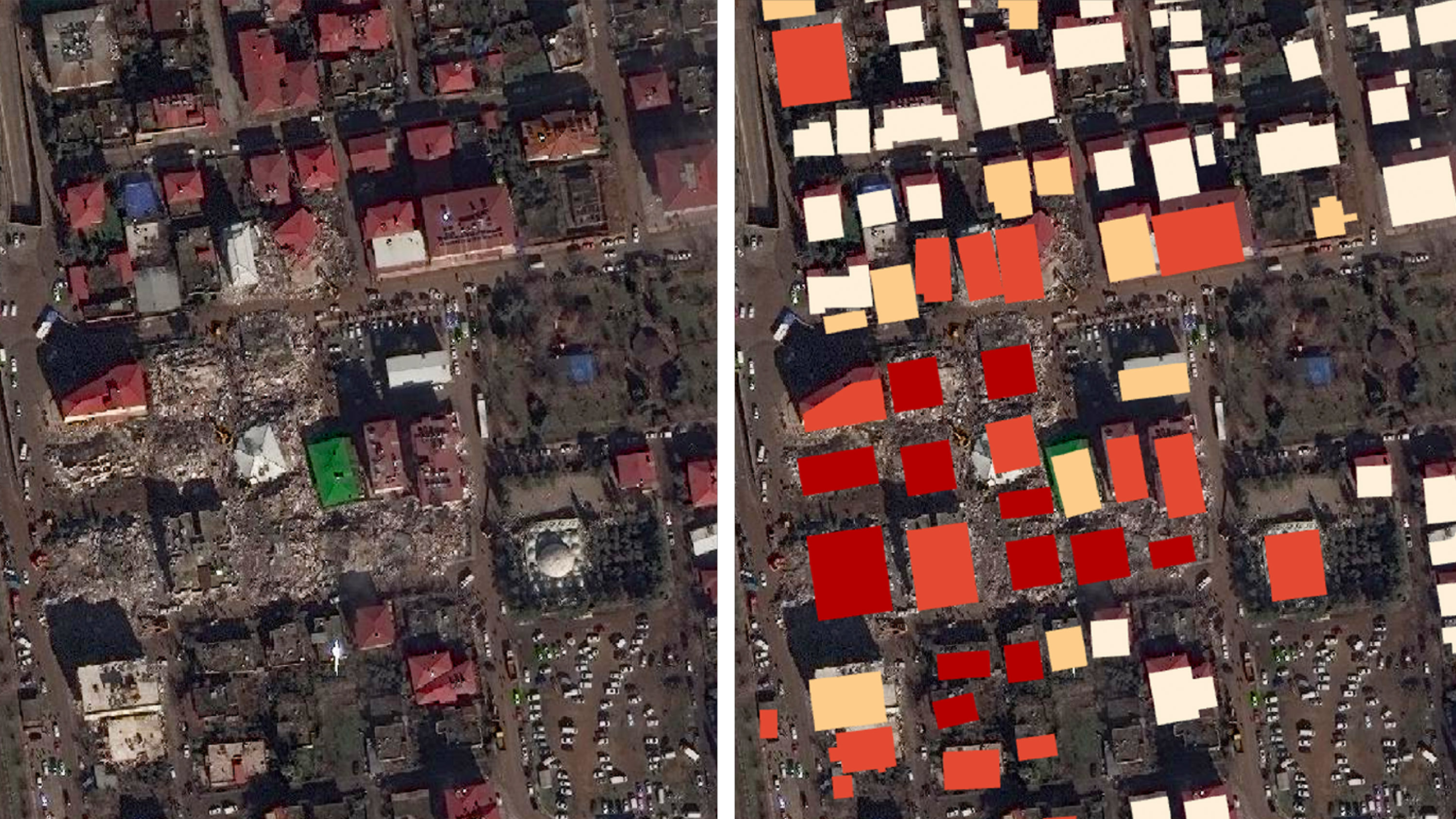
Islahiye, Turkey - Satellite image by Maxar Technologies (left) and xView2 image by UC Berkeley/Defense Innovation Unit/Microsoft (right)
(Source: MIT Technology Review )
AI has played a significant role in making damage assessment systems smarter.
2. AI Alerts: Guardians Before Danger Arrives
If the damage assessment is 'defensive' Early Warning Systems are like 'lifesavers'. Outpost.
The AI in this system acts like a tip, waiting to 'listen'. The earliest signs of an earthquake (i.e., the primary wave, or P-wave), which travels faster. Secondary waves (S-waves) and surface waves are severe damage agents. When the signal is detected, the AI system will quickly calculate the epicenter, magnitude, and risk area, and immediately sound the alarm.
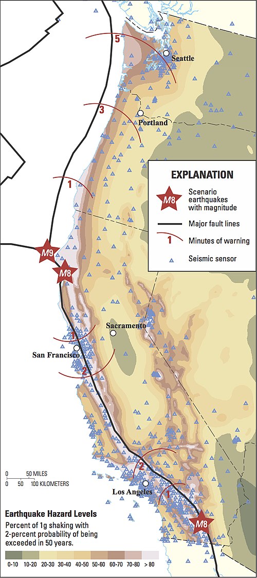
- An example that is clearly visible is ShakeAlert (Earthquake Early Warning - EEW) used in the West Coast of America. The system uses thousands of seismic sensors that work with AI to send an alarm to the school. Or even order automation to work, such as stopping trains, cutting off power at risk points, or opening the fire station garage door at your disposal!
- Just a few seconds before a strong tremor arrives could mean that many lives are spared, or that the damage is greatly reduced (the accuracy of forecasting weeks in advance is another part of more complex research. The main function of ShakeAlert is to alert immediately after it is detected.)

3. Decoding earthquakes: When AI reads the Earth's mind
Seismic data is complicated, and traditional analysis may overlook important signals.
But AI, especially Machine Learning (ML) techniques that are good at finding Hidden Patterns is coming to help 'decipher' this information more deeply.
It allows scientists to see. Precursor Signals It can be used in conjunction with other technologies such as Synthetic Aperture Radar (SAR) or sensor-mounted drones to create more detailed seismic maps.
There are interesting stories.
- As Los Alamos researchers use ML to 'listen' Vibration signals from Mount Kīlauea in Hawaii have revealed a pattern of stress loading cycles that may help better predict eruptions or subsequent earthquakes.
- Stanford has PhaseNet and CRED, which are ideas from the medical industry and voice assistant systems to help detect the arrival time of P/S waves (P/S Wave Arrival Picking) and microearthquakes hidden in seismic noise.
- In major cities like Tokyo or Los Angeles, AI can help create more accurate risk modeling/mapping, or even predict earthquake magnitude very closely.
4. AI in the real field: when disaster strikes
Now, let's take a look at the actual incident and how AI is used in real events.
- Turkey-Syria (2023): In addition to satellite imagery systems such as xView2, AI was also used to track data from social media to find out where people are in urgent need of help, or to display data on crisis mapping platforms in real time.
- Palu, Indonesia (2018): After the Great Earthquake and Tsunami The research team uses AI techniques such as Artificial Neural Networks (ANNs) and Support Vector Machines (SVMs) to analyze satellite imagery. It is a map of damage from earthquakes, tsunamis, and landslides, helping to plan evacuation and recovery on target.
In the future, AI will help more.
Looking ahead, the potential of AI in earthquake response still has a long way to go.
Think about how granular data we can get in real time if we combine AI with tiny sensors or Internet of Things (IoT) devices scattered across cities.
Or if there is a Quantum Computing that calculates super fast to help build models, including development. Real-time processing may be faster and more accurate earthquake predictions.
But it's not that easy...
Limitations and Challenges of AI
Even though AI looks bright. However, there are still many challenges in applying it to earthquakes, both technical, spatial and human.
1. Data Bias
-
Can the alarm system be missed? - Yes, especially systems that use a single point sensor or try to predict the severity of the P-wave alone. Sometimes there are 'false alarms'. It can happen.
- Technical Development such as Ensemble Learning Combining decisions from multiple AI models may improve accuracy and reduce this problem, but it is still a challenge.
- Biased data? - How good an AI model will be depends on the data used to teach it (Training Data). If most of the data comes from developed countries, When used in other areas with different conditions, there may be geographic bias or problems. Imbalanced data between large and small earthquakes can make predicting severe events less accurate.
2. Compare Technology:
When using AI to assess damage from photos, there are two main techniques:
- CNN (As mentioned at the beginning): Like a person who sees the big picture quickly, good at quickly classifying damage. It doesn't use a lot of processing power, but you may miss small details or tell the exact boundaries.
- Semantic Segmentation (the way xView2 uses): This is like a pixel-level deep look. It is much more accurate in identifying the extent of damage, suitable for detailed mapping, but requires more time and processing power, and requires training data. High-quality Annotated Data
3. Practical Challenges:
- Is the infrastructure ready? Remote areas may not yet have strong internet or electricity stable enough to keep the system running at all times.
- The development of technologies like Edge Computing, which allows data to be processed directly by sensors or end devices, may be a solution for areas where connectivity is unstable, but there are still budget and maintenance challenges.
- Are servants a servant? Staff must be trained to use the system to maintain it and must keep updating their knowledge because technology is fast.
- How to connect to the old system? System Integration: Bringing a new AI system to an existing legacy system may not be easy, but you also need to look at interoperability and data security.
Conclusion: AI from 'Defender' to 'Companion' in Earthquake Relief
It can be seen that AI is no longer just a high-tech tool, but is becoming a 'companion'. An important person who really helped us cope with the earthquake better.
From the quick damage assessment like a wing. From alarms that buy valuable time, to deeper data analysis.
But of course, there is still room for improvement, both in terms of technique, space readiness and human development.
So how do we move forward?
Making AI a force to protect us from earthquakes to its full potential Both the public and private sectors must be serious about investing in research and development. This makes the technology more accurate, reduces bias, and is practical even in scarce areas.
Sharing knowledge and technology between countries is equally important. Because this is a global problem. Meanwhile, Educating the public to understand and take advantage of various warning systems, as well as developing people to be ready to use new technologies, is the key to helping us all move towards a safer future from earthquakes. With the power of AI.
References
1. ShakeAlert System
- Official Website: http://www.shakealert.org
- USGS ShakeAlert
- USGS ShakeAlert Test News Release
2. xView2 Project
- xView2 Official Website
- GitHub Repository - xView2 First Place
- GitHub - xView2 Challenge Code (ethanweber)
- Ultralytics YOLO Docs - xView Dataset
- IBM - The xView2 AI Challenge
- Defense Innovation Unit - xView Challenge
- Fast.ai Forums - xView2 Project
- xView Dataset Official Website
- Remote Sensing Research -- xView2 Paper
3. Stanford AI Models
4. Turkey-Syria Earthquake 2023
- USGS Event Page
- UN Disaster Assessment -- OCHA
- Planet -- Response to Earthquakes
- MIT Technology Review -- AI in Disaster Response
5. Hokkaido Earthquake of 2018
7. Los Alamos National Laboratory
8. Hiroshima University
9. Carnegie Mellon University
Insiderly Selection Tools
Introducing selected AI tools
Get updates delivered straight to your email
Become a part of Insiderly's learning community. ❤️😊